


Typhoon Kanun, coming to Korea…from when to when?
![The expected path of Typhoon Kanun No. 6 announced by the Korea Meteorological Administration at 10:00 am on the 8th. [Provided by the Korea Meteorological Administration. Resale and DB prohibited]](https://img3.yna.co.kr/etc/inner/KR/2023/08/08/AKR20230808073100530_01_i_P4.jpg)
Typhoon Kanun is expected to land in Korea on the morning of the 10th, and is currently heading north from Japan to Korea.
Currently, Typhoon Kanun is approaching Kyushu in southwestern Japan while it hits Okinawa, Japan, and is accompanied by heavy rain and strong winds with an expected precipitation of 400mm, the largest typhoon Kanun in a day.
In preparation for Typhoon Kanun’s sixth typhoon heading north on the Korean Peninsula, the government has begun an emergency inspection of disaster risk areas. On the morning of the 8th, the Central Disaster and Safety Countermeasure Headquarters of the Ministry of Public Administration and Security held a meeting on this topic and discussed key management items and response plans for each institution in preparation for typhoons.
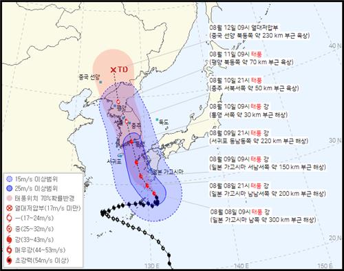
![Estimated path of Kanun in neighboring countries. [Provided by the Korea Meteorological Administration. Resale and DB prohibited]](https://img2.yna.co.kr/etc/inner/KR/2023/08/08/AKR20230808073100530_02_i_P4.jpg)
The central air pressure of Typhoon Kanun, which gradually moves north through the Japanese archipelago to the Korean peninsula, is 970 hPa (hectopascal), and the maximum wind speed near the center is 30 m/s and the maximum wind speed is 40 m/s. In the area within a radius of 200 km from the center of Typhoon Kanun, strong winds of more than 25m per second are blowing, and when it lands in Korea, the intensity of Typhoon Kanun is expected to remain ‘strong’.
According to the Korea Meteorological Administration, Typhoon Kanun is expected to land on the southern coast of Gyeongnam on the morning of the 10th, pass through the inland, and move to North Korea on the morning of the 11th. Heavy rain and strong winds are expected.
Accordingly, 10 cities and provinces, 33 cities, counties, and gu disaster risk improvement district maintenance sites and disaster risk areas such as steep slopes, reservoirs, and small rivers were urgently inspected in preparation for Typhoon Kanun. In addition, it plans to actively utilize available promotional media, such as disaster text messages, forecasts and warning systems, and village broadcasting, so that tips for public action according to weather and field conditions can be quickly delivered.
Editor Miso