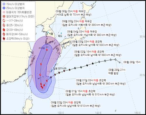
Super strong typhoon forecast to pass near Jeju Island early next week

SEOUL, Sept. 1 (Yonhap) — A super strong typhoon is approaching the Korean Peninsula, and the southern resort island of Jeju may come under its direct influence early next week, the state weather agency said Thursday.
Typhoon Hinnamnor, the 11th tropical storm of this year, is expected to move southwest to the sea 610 km south-southwest of Japan’s Okinawa Island at 3 a.m. Friday before turning north, the Korea Meteorological Administration (KMA) said.
After that, Hinnamnor is forecast to move quickly northward and reach the sea 70 km south of Jeju’s southern port city of Seogwipo next Tuesday, the KMA said.
The typhoon is classified as super strong, as it has an atmospheric pressure of 915 hectopascals at its center and a maximum wind speed of 55 mps.
When Hinnamnor reaches the sea off Jeju, it may grow stronger with an atmospheric pressure of 940 hectopascals and a maximum wind speed of 47 mps, the agency said, noting a storm with a maximum wind speed of 44 mps to 54 mps can blow people or large stones away.
Japan’s weather agency forecast that Hinnamnor may come to the sea southeast of Jeju at 3 a.m. on Sept. 6 with a central pressure of 945 hectopascals and a maximum wind speed of 45 mps, while the Joint Typhoon Warning Center of the United States expects it to pass through the eastern seas of Jeju on Sept. 5.


